GEOTECHNICALENGINEERING
PICKERING
HomeGeophysicsSeismic tomography (refraction/reflection)

Seismic Tomography (Refraction & Reflection) Surveys in Pickering

Sound ground. Sound decisions.

LEARN MORE

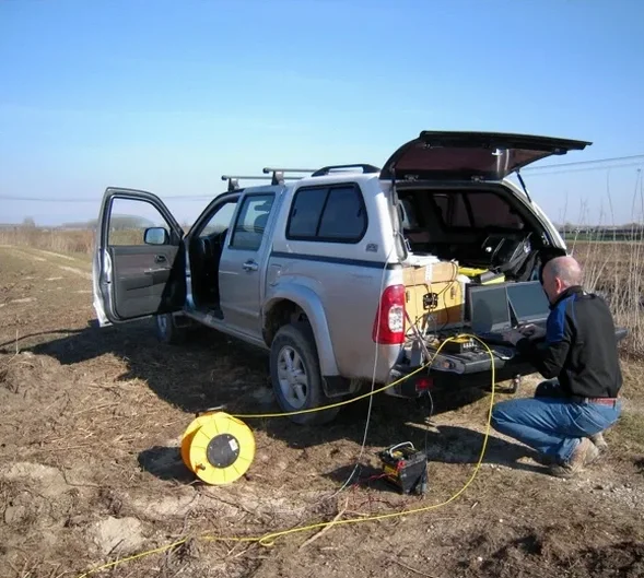
A three-storey office complex off Kingston Road hit unexpected weathered shale at 14 metres — right where the borehole log showed competent rock. The contractor lost three weeks and CA$80,000 in change orders. That scenario replays across Pickering more often than anyone admits, and it usually traces back to sparse drilling alone without geophysical cross-check. Seismic refraction and reflection tomography plug that gap: we shoot a linear geophone spread across the site, record P-wave and S-wave travel times, and invert the data into a continuous velocity cross-section that reveals lateral changes no single borehole can catch. Whether it is the glacial till overlying the Georgian Bay Formation or the buried valleys that thread through the Duffins Creek watershed, the velocity contrast between overburden and bedrock stands out sharply. We run the survey, process the picks with iterative ray-tracing, and deliver a 2D profile tied to your geotechnical grid. For deeper targets, seismic refraction handles 30–60 m penetration with a 120 m spread, while reflection mode reaches beyond 100 m when the site geometry allows it.

A velocity cross-section calibrated with just two boreholes can resolve bedrock topography across a 200-metre transect within half a metre.

Our service areas

Our approach and scope

The field setup we deploy in Pickering uses a 24-channel seismograph with 4.5 Hz vertical geophones spaced at 3 to 5 metres, depending on the resolution target. The source alternates between a 10 kg sledgehammer on a steel plate for shallow shots and a weight-drop system when we need more energy to punch through the dense Halton Till. A single line takes about two hours to lay out, shoot, and stack; we typically run three to five lines per site, oriented parallel and perpendicular to the proposed excavation footprint. On the processing side, first-break picking feeds into a tomographic inversion that iterates until the RMS error drops below 2 %. The output is a colour-contoured velocity section — reds for soil, blues for rock — that we calibrate against spt-drilling data from the same grid. This calibration step is non-negotiable because the velocity of a saturated silty sand can mimic a weak claystone if left unchecked. We also extract Poisson's ratio maps from combined P- and S-wave surveys, which help identify zones of low stiffness before a shovel ever breaks ground. An in-situ permeability test in the borehole provides the hydrogeological tie-in when groundwater affects seismic attenuation.
Seismic Tomography (Refraction & Reflection) Surveys in Pickering
Technical reference — Pickering

Local geotechnical context

The most common misstep we see in Pickering is treating a single seismic line as a site-wide bedrock map. A north-south line along the proposed building footprint will miss east-west depressions in the rockhead — and the buried valleys carved into the Georgian Bay shale can drop 8 metres over a 40-metre lateral distance. We reviewed a 2021 project near Frenchman's Bay where the excavation plan assumed a flat rock profile based on one refraction line; the contractor hit a trough on the east corner and spent two weeks hammering and mucking saturated till. The fix is straightforward: run at least two orthogonal lines, tie them at the intersection, and cross-check with cpt-test soundings at the interpreted low-velocity zones. Another trap is assuming that high velocity equals high strength — weathered shale can return 2,200 m/s and still slake within 48 hours of exposure. We flag those intervals explicitly in the rippability chart so the earthworks team knows where a ripper tooth becomes a pick and shovel.

Need a geotechnical assessment?

Reply within 24h.

Email: info@geotechnicalengineering.co

Regulatory framework

NBCC 2020 (National Building Code of Canada), CSA A23.3-19 (Design of Concrete Structures), ASTM D5777-18 (Standard Guide for Selecting Surface Geophysical Methods), ASTM D7128-18 (Standard Guide for Using the Seismic-Reflection Method), OPSS 206 (Ontario Provincial Standard Specification for Geophysical Investigation)

Typical values

ParameterTypical value
Seismic sourceSledgehammer / weight drop / buffalo gun
Geophone array24-ch, 4.5 Hz vertical, 3–5 m spacing
Typical penetration (refraction)30–60 m with 120 m spread
Typical penetration (reflection)>100 m (target-dependent)
Tomographic inversion RMS< 2 % after 10–15 iterations
Output deliverables2D velocity sections, Poisson's ratio maps, rippability charts
Calibration requirementMinimum 2 boreholes or CPT soundings per line

Quick answers

How deep can seismic refraction see in the Pickering area?

With a 120-metre geophone spread and a weight-drop source, refraction reliably images to 40–60 metres in the glacial deposits and shale bedrock typical of Pickering. Depth is limited by the velocity structure — a thin high-velocity layer can blind what sits beneath — so we cross-check with reflection profiling when targets exceed 60 metres.

What does a seismic tomography survey cost for a typical Pickering lot?

For a standard commercial or industrial lot in Pickering, seismic tomography ranges from CA$3,690 to CA$6,610, depending on the number of lines, geophone spacing, and whether both P-wave and S-wave data are acquired. We provide a fixed-price scope after reviewing the site geometry and target depth.

Can you run seismic lines inside an existing building or on paved surfaces?

Yes, with constraints. Geophones can be mounted on asphalt or concrete using metal base plates and adhesive wax; the source energy is reduced, so penetration depth drops. Inside buildings, we use a smaller hammer source and shorter spreads, which works for slab thickness and subgrade assessment but not for deep bedrock mapping.

How many boreholes do you need to calibrate a seismic survey?

The reference range for this service in Pickering is CA$3.690 - CA$6.610. The final price depends on the project scope and volume.

Location and service area

We serve projects in Pickering and surrounding areas.

View larger map